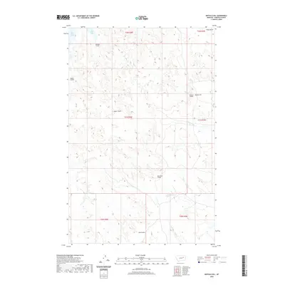
2020 Map of Buffalo Hill
USGS Topo · Published 2020About this map
Fort Peck Lake defines the northwestern corner of this Garfield County landscape, where the Missouri River's impounded waters reach into the Missouri Breaks. The terrain is characterized by a complex system of drainage ravines, including Burdick Coulee and Jasper Coulee, which carve through the high plains toward the reservoir. These ephemeral watercourses illustrate the intricate erosion patterns typical of this portion of eastern Montana, where the land rises toward high points like Buffalo Hill and the Piney Buttes. Further south, the map details the headwaters of the N Fork Woody Cr and S Fork Woody Cr, offering a clear look at the watershed divide between the lake's direct tributaries and the drainage systems feeding into the larger Missouri basin. The absence of modern development highlights the preserved ranching and public land character of the region as it appeared in 2020.
Find a feature on this map
16 named features on this map. Tap any name to fly to it.
Don’t see what you’re looking for? This feature index may not catch every label — zoom into the map to look around manually.
Map Details
Editions of this 2020 Buffalo Hill Map
This is the sole edition of this map. No revisions or reprints were ever made.
Other maps of this area

1954 · Jordan
USGS Topo · 1:250,000

1956 · Jordan
USGS Topo · 1:250,000

1958 · Jordan
USGS Topo · 1:250,000

1958 · Maloney Hill
USGS Topo · 1:62,500

1964 · Jordan
USGS Topo · 1:250,000

1964 · Jordan NE
USGS Topo · 1:24,000

1964 · Bateman Coulee
USGS Topo · 1:24,000

1964 · Jordan NW
USGS Topo · 1:24,000
1972 · Kester School
USGS Topo · 1:24,000
1972 · Signal Butte
USGS Topo · 1:24,000