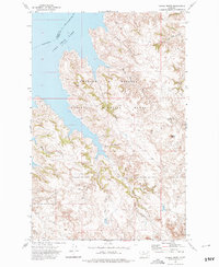
1972 Map of Signal Butte
USGS Topo · Published 1975About this map
The waters of Fort Peck Lake dominate this 1970s landscape, illustrating the scale of the Missouri River's transformation in Garfield and Valley counties. Much of the terrain falls within the Charles M Russell National Wildlife Range, a protected expanse characterized by intricate drainage systems such as Bunn Coulee and Sheep Coulee. The presence of the Cole Ranch near the center of the sheet indicates the ongoing legacy of ranching in this sparsely populated region, where human activity is limited to remote outposts and intermittent water sources like Swallow Nest Spring.
Find a feature on this map
14 named features on this map. Tap any name to fly to it.
Don’t see what you’re looking for? This feature index may not catch every label — zoom into the map to look around manually.
Map Details
Editions of this 1972 Signal Butte Map
This is the sole edition of this map. No revisions or reprints were ever made.
Other maps of this area

1954 · Jordan
USGS Topo · 1:250,000

1956 · Jordan
USGS Topo · 1:250,000

1958 · Jordan
USGS Topo · 1:250,000

1958 · Collins Ranch
USGS Topo · 1:62,500

1958 · Maloney Hill
USGS Topo · 1:62,500

1958 · Sage Creek Point
USGS Topo · 1:24,000
1958 · Seventh Point Buttes
USGS Topo · 1:24,000

1964 · Jordan
USGS Topo · 1:250,000
1972 · Kester School
USGS Topo · 1:24,000
1972 · Gilbert Creek SE
USGS Topo · 1:24,000