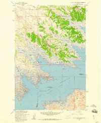
1958 Map of Seventh Point Buttes
USGS Topo · Published 1960About this map
Fort Peck Reservoir (Missouri River) dominates the southern half of this landscape, its intricate, branching shoreline carving deep into the rugged breaks of northern Montana. This 1958 survey captures the region as a dedicated conservation and recreation landscape within the Fort Peck Game Range. A series of prominent landforms, including the Seventh Point Buttes and Bell Point, rise above the water, separated by a sequence of dramatic drainages like Seventh Point Coulee and The Sag. The northern uplands are characterized by alternating ridges and coulees, from Fourth Ridge down to Lower Eighth Coulee, illustrating the erosional patterns typical of the Missouri River Basin. Human presence is concentrated at The Pines Recreation Area and a nearby Youth Camp, with access limited to unimproved dirt tracks that follow the high ground between the coulees.
Find a feature on this map
17 named features on this map. Tap any name to fly to it.
Don’t see what you’re looking for? This feature index may not catch every label — zoom into the map to look around manually.
Map Details
Editions of this 1958 Seventh Point Buttes Map
2 editions found
Other maps of this area

1954 · Jordan
USGS Topo · 1:250,000

1956 · Jordan
USGS Topo · 1:250,000

1958 · Jordan
USGS Topo · 1:250,000

1958 · Collins Ranch
USGS Topo · 1:62,500

1958 · Maloney Hill
USGS Topo · 1:62,500

1958 · Lewis Reservoir
USGS Topo · 1:24,000

1958 · Sage Creek Point
USGS Topo · 1:24,000
1958 · Skunk Coulee
USGS Topo · 1:24,000

1964 · Jordan
USGS Topo · 1:250,000
1972 · Gilbert Creek
USGS Topo · 1:24,000