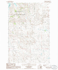
1986 Map of Buffalo Hill
USGS Topo · Published 1986About this map
The Charles M Russell National Wildlife Refuge dominates this northern Montana landscape, protecting a complex system of drainages that feed into the massive Fort Peck Lake reservoir. The topography is defined by the transition from high points like Buffalo Hill down into deeply eroded coulees, including Johnson Coulee and Bullock Coulee, which channel seasonal runoff toward the Missouri River breaks. The southern portion of the map shows the upper reaches of the Woody Creek system, with both the North Fk Woody Creek and South Fork Woody Creek carving through the prairie. While primarily a protected wilderness, evidence of resource exploration is visible through several marked wells. This survey captures the area at a time when the Hell Creek Bay region remained a focal point for both conservation and quiet recreation in Garfield County.
Find a feature on this map
14 named features on this map. Tap any name to fly to it.
Don’t see what you’re looking for? This feature index may not catch every label — zoom into the map to look around manually.
Map Details
Editions of this 1986 Buffalo Hill Map
This is the sole edition of this map. No revisions or reprints were ever made.
Other maps of this area

1954 · Jordan
USGS Topo · 1:250,000

1956 · Jordan
USGS Topo · 1:250,000

1958 · Jordan
USGS Topo · 1:250,000

1958 · Maloney Hill
USGS Topo · 1:62,500

1964 · Jordan
USGS Topo · 1:250,000

1964 · Jordan NE
USGS Topo · 1:24,000

1964 · Bateman Coulee
USGS Topo · 1:24,000

1964 · Jordan NW
USGS Topo · 1:24,000
1972 · Kester School
USGS Topo · 1:24,000
1972 · Signal Butte
USGS Topo · 1:24,000