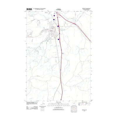
2012 Map of Buffalo
USGS Topo · Published 2012About this map
Buffalo sits at the foot of the Bighorn Mountains, serving as the central hub of this Johnson County landscape. The town's grid is defined by a network of local thoroughfares like Upper Clear Creek Rd and Veterans Ln, while the Johnson County Airport occupies the northern plateau. The agricultural character of the region is evident in the intricate system of man-made waterways, including Sixmile Ditch, Crown Ditch, and Redman Ditch, which divert water from natural courses like Clear Cr and French Cr to sustain the high plains. Outside the developed center, the terrain is marked by seasonal drainages and geographic depressions such as Dump Draw and McVenry Draw. To the south, the landscape opens into broader drainages where Bull Cr and its tributaries, including S Fork Bull Cr, carve through the expansive ranch lands.
Find a feature on this map
63 named features on this map. Tap any name to fly to it.
Don’t see what you’re looking for? This feature index may not catch every label — zoom into the map to look around manually.
Map Details
Editions of this 2012 Buffalo Map
This is the sole edition of this map. No revisions or reprints were ever made.
Other maps of this area

1900 · Fort McKinney
USGS Topo · 1:125,000

1903 · Fort McKinney
USGS Topo · 1:125,000

1955 · Sheridan
USGS Topo · 1:250,000

1958 · Sheridan
USGS Topo · 1:250,000

1962 · Sheridan
USGS Topo · 1:250,000

1967 · Lake De Smet West
USGS Topo · 1:24,000
1967 · Klondike Ranch
USGS Topo · 1:24,000
1967 · North Ridge
USGS Topo · 1:24,000
1970 · Buffalo
USGS Topo · 1:24,000

1970 · Buffalo NE
USGS Topo · 1:24,000