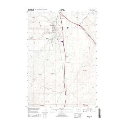
2015 Map of Buffalo
USGS Topo · Published 2015About this map
Buffalo sits as the central hub of this Johnson County landscape, where the modern interstate system intersects with a complex network of historic irrigation and ranching infrastructure. The town's grid is bounded by notable landmarks such as Willow Grove Cem, while the surrounding terrain is defined by a sophisticated system of water management. Numerous channels like Redman Ditch, Sixmile Ditch, and the Johnson County Ditch underscore the region's agricultural reliance on diverted water from natural courses like Clear Creek and French Cr. The map reveals the transition from the concentrated residential streets of Buffalo to the expansive drainage basins of McVenry Draw and Gossett Draw. This topographic study provides a detailed view of the local road network, from named city streets like Sunset Ave and Fort St to rural connectors like French Creek Rd.
Find a feature on this map
86 named features on this map. Tap any name to fly to it.
Don’t see what you’re looking for? This feature index may not catch every label — zoom into the map to look around manually.
Map Details
Editions of this 2015 Buffalo Map
This is the sole edition of this map. No revisions or reprints were ever made.
Other maps of this area

1900 · Fort McKinney
USGS Topo · 1:125,000

1903 · Fort McKinney
USGS Topo · 1:125,000

1955 · Sheridan
USGS Topo · 1:250,000

1958 · Sheridan
USGS Topo · 1:250,000

1962 · Sheridan
USGS Topo · 1:250,000

1967 · Lake De Smet West
USGS Topo · 1:24,000
1967 · Klondike Ranch
USGS Topo · 1:24,000
1967 · North Ridge
USGS Topo · 1:24,000
1970 · Buffalo
USGS Topo · 1:24,000

1970 · Buffalo NE
USGS Topo · 1:24,000