1978 Map of Buffalo
USGS Topo · Published 1979About this map
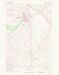
Buffalo sits as the primary hub of this high-plains landscape, where the foothills of the Bighorn National Forest meet the drainage basins of the Powder River. The map documents a critical transition in Northern Wyoming water management and transport, featuring prominent landmarks like Lake De Smet and the Healy Reservoir. Settlement patterns follow the erratic courses of Crazy Woman Creek and the Middle Fork Powder River, with small outposts like Hazelton, Trabing, and Four Corners marking the intersections of ranching life and early mountain transit. The survey captures the region as Interstate 90 and U.S. Highway 16 consolidated their roles in the local economy, connecting the sprawling timberlands of Bald Ridge to the eastern draws of the Kinney Divide. The sheer density of named draws, including Poison Creek and Dry Creek, highlights the complex hydrology required to sustain high-altitude ranching during this era.
Find a feature on this map
38 named features on this map. Tap any name to fly to it.
Don’t see what you’re looking for? This feature index may not catch every label — zoom into the map to look around manually.
Map Details
Editions of this 1978 Buffalo Map
This is the sole edition of this map. No revisions or reprints were ever made.
Historical Maps of Buffalo Through Time
3 maps found