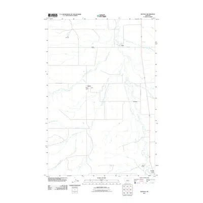
2011 Map of Buffalo
USGS Topo · Published 2011About this map
Buffalo and the nearby settlement of Straw anchor this 2011 survey of Fergus County, Montana. The landscape is defined by the drainage network of Buffalo Creek and Ross Fork, with the West Buffalo Creek and Mud Creek systems cutting across the plains. These water sources historically dictated the location of early homesteads and small railroad stops in this agricultural region. Evidence of community life is found at the Buffalo Post Office and local burial sites including Buffalo Cemetery and Garneill Cemetery in the southern portion of the quadrangle. Smaller named locales such as McClave and Monk Coulee appear alongside infrastructure like the Bye-Bye Dam. The layout of local routes, such as Straw Rd and Buffalo Canyon Rd, reveals how the rural population centers were connected to larger markets and surrounding grazing lands.
Find a feature on this map
22 named features on this map. Tap any name to fly to it.
Don’t see what you’re looking for? This feature index may not catch every label — zoom into the map to look around manually.
Map Details
Editions of this 2011 Buffalo Map
This is the sole edition of this map. No revisions or reprints were ever made.
Other maps of this area

1889 · Big Snowy Mountain
USGS Topo · 1:250,000

1893 · Big Snowy Mountain
USGS Topo · 1:250,000

1954 · Roundup
USGS Topo · 1:250,000

1958 · Roundup
USGS Topo · 1:250,000
1970 · Buffalo
USGS Topo · 1:24,000

1970 · Moore
USGS Topo · 1:24,000
1970 · Martin Coulee
USGS Topo · 1:24,000
1970 · Ackley Lake
USGS Topo · 1:24,000
1970 · Moore SW
USGS Topo · 1:24,000
1970 · Sipple
USGS Topo · 1:24,000