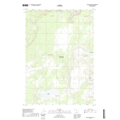
2017 Map of Buffalo Meadows
USGS Topo · Published 2017About this map
Yellowstone National Park encompasses this entire high-altitude landscape, where geothermal activity and alpine watersheds define the terrain. The central hydrology is dominated by Sentinel Cr, which meanders through the broad, open expanse of Sentinel Meadows. To the south, the topography rises toward Twin Buttes, a prominent landmark overlooking the Imperial Geyser. This geyser serves as a focal point for the hydrothermal features concentrated in the southeastern portion of the map. The namesake Buffalo Meadows occupies the southwest, providing a distinct contrast to the more forested slopes and creek drainages. Movement through this wilderness is traced via the Fairy Creek Trail, which follows the course of Fairy Cr, connecting the geyser basins with the meadows and higher elevations. The map provides precise documentation of these natural landmarks within the Teton County portion of the park, capturing the undisturbed state of this famous thermal region.
Find a feature on this map
14 named features on this map. Tap any name to fly to it.
Don’t see what you’re looking for? This feature index may not catch every label — zoom into the map to look around manually.
Map Details
Editions of this 2017 Buffalo Meadows Map
This is the sole edition of this map. No revisions or reprints were ever made.
Other maps of this area

1885 · Gallatin
USGS Topo · 1:125,000

1885 · Gallatin
USGS Topo · 1:125,000

1886 · Shoshone
USGS Topo · 1:125,000

1888 · Shoshone
USGS Topo · 1:125,000

1895 · Shoshone
USGS Topo · 1:125,000

1901 · Shoshone
USGS Topo · 1:125,000

1901 · Gallatin
USGS Topo · 1:125,000

1908 · Gallatin
USGS Topo · 1:125,000

1908 · Shoshone
USGS Topo · 1:125,000

1911 · Shoshone
USGS Topo · 1:125,000