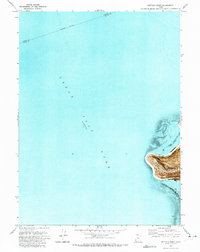
1972 Map of Buffalo Point
USGS Topo · Published 1973About this map
Antelope Island rises from the turquoise expanse of the Great Salt Lake in this 1972 orthophotomap. The Northwestern portion of the island is dominated by the prominent landform of Buffalo Point, which looks out over the transition between Bridger Bay and White Rock Bay. This survey captures the island during its early years as a protected public space following the establishment of Great Salt Lake State Park, showing the limited road access and natural water sources such as Buffalo Spring. The map is unique for its use of an orthophotomosaic base, which provides a photographic texture to the terrain and water, including the isolated outcrop of Egg Island and the distinctive White Rock near the island's western shoreline. An indefinite boundary marks the watery division between Weber and Davis Counties across the lake surface.
Find a feature on this map
11 named features on this map. Tap any name to fly to it.
Don’t see what you’re looking for? This feature index may not catch every label — zoom into the map to look around manually.
Map Details
Editions of this 1972 Buffalo Point Map
This is the sole edition of this map. No revisions or reprints were ever made.
Other maps of this area

1885 · Tooele Valley
USGS Topo · 1:250,000

1953 · Tooele
USGS Topo · 1:250,000

1954 · Antelope Island
USGS Topo · 1:24,000

1954 · Antelope Island North
USGS Topo · 1:24,000

1954 · Brigham City
USGS Topo · 1:250,000

1955 · Ogden Bay
USGS Topo · 1:24,000

1955 · Fremont Island
USGS Topo · 1:24,000

1955 · Tooele
USGS Topo · 1:250,000

1958 · Brigham City
USGS Topo · 1:250,000

1962 · Brigham City
USGS Topo · 1:250,000