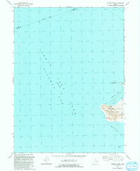
1991 Map of Buffalo Point
USGS Topo · Published 1991About this map
Antelope Island State Park dominates the eastern margin of this map, representing a significant landmass within the fluctuating waters of the Great Salt Lake. This 1991 revision, based on earlier aerial photography from 1965 and 1987, highlights the dramatic shoreline of Antelope Island at a specific historical water level. The western face of the island is marked by prominent topographic features such as Buffalo Point and the essential freshwater source at Buffalo Spring.
Find a feature on this map
14 named features on this map. Tap any name to fly to it.
Don’t see what you’re looking for? This feature index may not catch every label — zoom into the map to look around manually.
Map Details
Editions of this 1991 Buffalo Point Map
This is the sole edition of this map. No revisions or reprints were ever made.
Other maps of this area

1885 · Tooele Valley
USGS Topo · 1:250,000

1953 · Tooele
USGS Topo · 1:250,000

1954 · Antelope Island
USGS Topo · 1:24,000

1954 · Antelope Island North
USGS Topo · 1:24,000

1954 · Brigham City
USGS Topo · 1:250,000

1955 · Ogden Bay
USGS Topo · 1:24,000

1955 · Fremont Island
USGS Topo · 1:24,000

1955 · Tooele
USGS Topo · 1:250,000

1958 · Brigham City
USGS Topo · 1:250,000

1962 · Brigham City
USGS Topo · 1:250,000