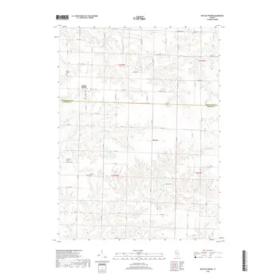
2018 Map of Buffalo Prairie
USGS Topo · Published 2018About this map
Buffalo Prairie sits atop the dissected plateau of the Illinois-Iowa borderlands, where the landscape is defined by a dense network of creek drainages carving through the upland. This survey captures the rural character of western Rock Island and Mercer Counties, anchored by the settlements of Marston and Buffalo Prairie. The terrain is marked by deep-set watercourses including Copperas Cr, Eliza Cr, and the Illinois Slough, which drain the agricultural tablelands. For genealogists, the map provides precise locations for the Edgington Cem, Buffalo Prairie Cem, and Duncan Cem. The road network, including the evocative Wayout Farm Rd, follows the section lines of the Public Land Survey System, illustrating how modern parceling remains tied to the historical township and range framework of the mid-nineteenth century.
Find a feature on this map
40 named features on this map. Tap any name to fly to it.
Don’t see what you’re looking for? This feature index may not catch every label — zoom into the map to look around manually.
Map Details
Editions of this 2018 Buffalo Prairie Map
This is the sole edition of this map. No revisions or reprints were ever made.
Other maps of this area

1912 · Milan
USGS Topo · 1:62,500

1916 · Edgington
USGS Topo · 1:62,500

1923 · Alexis
USGS Topo · 1:62,500

1925 · Alexis
USGS Topo · 1:62,500

1935 · Keithsburg
USGS Topo · 1:48,000

1938 · Edgington
USGS Topo · 1:62,500

1941 · Keithsburg
USGS Topo · 1:62,500

1944 · Milan
USGS Topo · 1:62,500

1953 · Buffalo Prairie
USGS Topo · 1:24,000
1953 · Illinois City
USGS Topo · 1:24,000