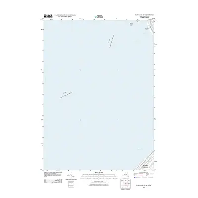
2011 Map of Buffalo SE OE W
USGS Topo · Published 2011About this map
Lake Erie and its strategic maritime corridor dominate this survey, defining the international boundary between the Canada and the United States. The industrial and nautical character of the Buffalo waterfront is evident along the northern edge, where the Buffalo Outer Harbor serves as a critical infrastructure hub. Navigation aids such as the Buffalo Harbor Light and North End Light mark the approach to the shipping channels, which are further defined by the Seaway Piers, including Pier 1 and Pier 2. In the southeastern corner, the residential community of Mount Vernon sits along the shoreline, representing one of the few developed land areas on this largely aquatic map. The layout reflects the ongoing importance of the Great Lakes shipping routes and the transition from traditional industrial pier use toward modern harbor management.
Find a feature on this map
9 named features on this map. Tap any name to fly to it.
Don’t see what you’re looking for? This feature index may not catch every label — zoom into the map to look around manually.
Map Details
Editions of this 2011 Buffalo SE OE W Map
This is the sole edition of this map. No revisions or reprints were ever made.
Other maps of this area

1894 · Buffalo
USGS Topo · 1:62,500

1899 · Silver Creek
USGS Topo · 1:62,500

1901 · Buffalo
USGS Topo · 1:62,500

1905 · Eden
USGS Topo · 1:62,500

1907 · Eden
USGS Topo · 1:62,500

1944 · Eden
USGS Topo · 1:62,500

1944 · Hamburg
USGS Topo · 1:31,680
1944 · Angola
USGS Topo · 1:31,680

1948 · Hamburg
USGS Topo · 1:24,000
1948 · Buffalo
USGS Topo · 1:62,500