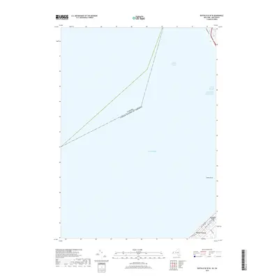
2019 Map of Buffalo SE OE W
USGS Topo · Published 2019About this map
Lake Erie dominates this nautical and coastal landscape south of Buffalo, where the international maritime boundary separates the United States and Canada. The shoreline is defined by the residential development of Mount Vernon and Locksley Park, where street networks like Mount Vernon Blvd and Kennison Pkwy meet the water's edge. Off the coast, the submerged geography of Seneca Shoal presents a significant feature for navigation, alongside the North Entrance Channel and the approach to the south entrance. Inland infrastructure is represented by Lake Shore Rd and Fuhrmann Blvd, which serve as the primary conduits along this stretch of the Erie County coast. This survey provides a precise record of the contemporary shoreline and the essential channels that facilitate commerce through the Great Lakes system.
Find a feature on this map
13 named features on this map. Tap any name to fly to it.
Don’t see what you’re looking for? This feature index may not catch every label — zoom into the map to look around manually.
Map Details
Editions of this 2019 Buffalo SE OE W Map
This is the sole edition of this map. No revisions or reprints were ever made.
Other maps of this area

1894 · Buffalo
USGS Topo · 1:62,500

1899 · Silver Creek
USGS Topo · 1:62,500

1901 · Buffalo
USGS Topo · 1:62,500

1905 · Eden
USGS Topo · 1:62,500

1907 · Eden
USGS Topo · 1:62,500

1944 · Eden
USGS Topo · 1:62,500

1944 · Hamburg
USGS Topo · 1:31,680
1944 · Angola
USGS Topo · 1:31,680

1948 · Hamburg
USGS Topo · 1:24,000
1948 · Buffalo
USGS Topo · 1:62,500