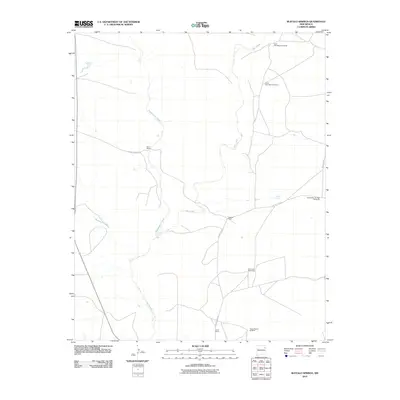
2010 Map of Buffalo Springs
USGS Topo · Published 2010About this map
Buffalo Springs and the surrounding ranchlands of Harding County characterize this 2010 landscape, where the survival of cattle operations depends on a network of water sources. The terrain is defined by the drainage systems of Ute Creek, Tequesquite Creek, and Mosquero Creek, which carve through the high plains. Human habitation is centered around established family holdings such as the Baca Ranch, Casados Ranch, and Garcia Ranch, reflecting a long-standing tradition of New Mexico ranching. A notable feature of this map is the distribution of named water infrastructure, including the North Casa Blanca Windmill, South Casa Blanca Windmill, and the East Buffalo Springs Windmills. These scattered points, along with the House Pasture Windmill and North Twin Windmills, illustrate the practical requirements of managing livestock in an arid environment where County Road H-3 and County Road H provide the primary links between these remote outposts.
Find a feature on this map
14 named features on this map. Tap any name to fly to it.
Don’t see what you’re looking for? This feature index may not catch every label — zoom into the map to look around manually.
Map Details
Editions of this 2010 Buffalo Springs Map
This is the sole edition of this map. No revisions or reprints were ever made.
Other maps of this area

1954 · Tucumcari
USGS Topo · 1:250,000

1958 · Tucumcari
USGS Topo · 1:250,000

1969 · Gallegos
USGS Topo · 1:24,000

1969 · Gallegos NE
USGS Topo · 1:24,000

1969 · Salitre Canyon
USGS Topo · 1:24,000
1969 · Alamosa Canyon
USGS Topo · 1:24,000

1969 · Buffalo Springs
USGS Topo · 1:24,000
1969 · Fuentes Ranch
USGS Topo · 1:24,000

1973 · Circle Bar Ranch
USGS Topo · 1:24,000
1973 · Indian Bathtub
USGS Topo · 1:24,000