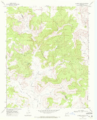
1969 Map of Alamosa Canyon
USGS Topo · Published 1972About this map
CA Camp and the nearby CA School anchor the northern landscape of this San Miguel County region, illustrating the self-contained ranching infrastructure common in New Mexico during the late 1960s. The terrain is deeply carved by a network of drainage systems, including Alamosa Canyon and Dog Canyon, where water management is critical to the local economy. An extensive system of livestock watering points—such as Persiliano Windmill, Fowl Windmill, and Pothole Tank—is scattered across the highlands and canyon floors.
Find a feature on this map
36 named features on this map. Tap any name to fly to it.
Don’t see what you’re looking for? This feature index may not catch every label — zoom into the map to look around manually.
Map Details
Editions of this 1969 Alamosa Canyon Map
This is the sole edition of this map. No revisions or reprints were ever made.
Other maps of this area

1930 · Tucumcari
USGS Topo · 1:125,000

1954 · Tucumcari
USGS Topo · 1:250,000

1958 · Tucumcari
USGS Topo · 1:250,000

1968 · Hampton Ranch
USGS Topo · 1:24,000

1968 · Carpenter Mesa NW
USGS Topo · 1:24,000
1968 · Medina Mesa
USGS Topo · 1:24,000

1969 · Gallegos
USGS Topo · 1:24,000

1969 · Salitre Canyon
USGS Topo · 1:24,000
1969 · Campana
USGS Topo · 1:24,000

1969 · Chinaberry Canyon
USGS Topo · 1:24,000