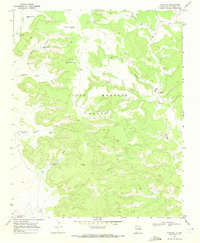
1969 Map of Campana
USGS Topo · Published 1972About this map
The Pablo Montoya Grant dominates this high-plains landscape in San Miguel County, where ranching infrastructure and remote canyon drainages define the area's geography. During the late 1960s, the small settlement of Campana served as a central point in this sparsely populated territory, situated near the Trigg Landing Strip and a local Water Tank. The terrain is characterized by a complex network of seasonal watercourses, including Atarque Creek and Medio Creek, which have carved deep features such as Muertos Canyon and Seco Canyon.
Find a feature on this map
22 named features on this map. Tap any name to fly to it.
Don’t see what you’re looking for? This feature index may not catch every label — zoom into the map to look around manually.
Map Details
Editions of this 1969 Campana Map
This is the sole edition of this map. No revisions or reprints were ever made.
Other maps of this area

1930 · Tucumcari
USGS Topo · 1:125,000

1954 · Santa Fe
USGS Topo · 1:250,000

1954 · Tucumcari
USGS Topo · 1:250,000

1958 · Santa Fe
USGS Topo · 1:250,000

1958 · Tucumcari
USGS Topo · 1:250,000

1968 · La Cinta Mesa
USGS Topo · 1:24,000

1968 · Carpenter Mesa NW
USGS Topo · 1:24,000
1968 · Medina Mesa
USGS Topo · 1:24,000

1969 · Salitre Canyon
USGS Topo · 1:24,000
1969 · Alamosa Canyon
USGS Topo · 1:24,000