
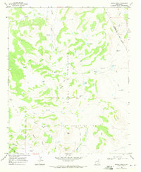
1968 Map of Carpenter Mesa NW
USGS Topo · Published 1971About this map
The Pablo Montoya Grant dominates this landscape in San Miguel County, showing a high-desert terrain defined by vital water management. During the late 1960s, this area relied on a network of named windmills and tanks to sustain ranching operations across the mesas. Features like the Doodlebug Windmill, Cow Pass Windmill, and Little Joe Windmill underscore the importance of wind-powered groundwater extraction in this arid environment. The drainage system is clearly marked by several ephemeral watercourses, including Chical Creek, Watrous Creek, and Saint Patrick Creek, which carve through the land toward Carpenter Mesa. For those tracing local history, the map provides a look at the specific placements of Saint Patrick Tank, Watrous Tank, and Tony Tank, which were essential landmarks in an otherwise sparsely populated territory.
Find a feature on this map
28 named features on this map. Tap any name to fly to it.
Don’t see what you’re looking for? This feature index may not catch every label — zoom into the map to look around manually.
Map Details
Editions of this 1968 Carpenter Mesa NW Map
This is the sole edition of this map. No revisions or reprints were ever made.
Other maps of this area

1930 · Tucumcari
USGS Topo · 1:125,000

1954 · Santa Fe
USGS Topo · 1:250,000

1954 · Tucumcari
USGS Topo · 1:250,000

1958 · Santa Fe
USGS Topo · 1:250,000

1958 · Tucumcari
USGS Topo · 1:250,000

1967 · Trinchera Creek
USGS Topo · 1:24,000

1967 · Monument Point
USGS Topo · 1:24,000

1968 · La Cinta Mesa
USGS Topo · 1:24,000

1968 · Carpenter Mesa SW
USGS Topo · 1:24,000
1968 · Medina Mesa
USGS Topo · 1:24,000