
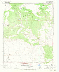
1967 Map of Trinchera Creek
USGS Topo · Published 1971About this map
The Canadian River cuts through this high desert landscape of San Miguel County, creating distinctive landmarks like the Horseshoe Bend and the towering Carpenter Mesa to the west. This 1967 survey documents a cattle-ranching economy dependent on an extensive network of water infrastructure, including the Conchas Canal in the south and dozens of named landmarks such as the Artesian Windmill, Llano Pens, and Trinchera Well. Large land grants dominate the interior, including the Montoya No 2 Location Baca and the South Boundary Montoya Pablo Grant. Evidence of earlier transport persists through an Old Railroad Grade north of the river and a winding Jeep Trail, while local operations like the Chappell-Spade Ranch mark the few centers of human settlement in this arid terrain.
Find a feature on this map
41 named features on this map. Tap any name to fly to it.
Don’t see what you’re looking for? This feature index may not catch every label — zoom into the map to look around manually.
Map Details
Editions of this 1967 Trinchera Creek Map
This is the sole edition of this map. No revisions or reprints were ever made.
Other maps of this area

1930 · Tucumcari
USGS Topo · 1:125,000

1954 · Tucumcari
USGS Topo · 1:250,000

1958 · Tucumcari
USGS Topo · 1:250,000

1967 · Liberty Mesa
USGS Topo · 1:24,000

1967 · Tucumcari
USGS Topo · 1:24,000

1968 · Bascom Camp
USGS Topo · 1:24,000

1968 · Hampton Ranch
USGS Topo · 1:24,000

1968 · Carpenter Mesa SW
USGS Topo · 1:24,000
1968 · Cow Canyon
USGS Topo · 1:24,000

1968 · Carpenter Mesa NW
USGS Topo · 1:24,000