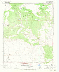
1968 Map of Cow Canyon
USGS Topo · Published 1971About this map
The Pablo Montoya Grant Boundary bisects this high desert landscape, marking a legacy of land tenure that predates the modern county lines of San Miguel and Quay counties. The terrain is defined by the massive plateau of Mesa Rica, which gives way to a complex network of drainages including Vigil Canyon, Cow Canyon, and Hondo Canyon. This late-1960s survey illustrates a specialized ranching economy dependent on dispersed water infrastructure, such as Hondo Tank, Elliott Tank, and the Spring Canyon Windmill. Along the southern edge, the Chicago Rock Island and Pacific railroad tracks and a major Pipeline run parallel to Arroyo de las Palomas, following the level ground south of the mesa. The presence of features like the North Privo Windmill and South Privo Tank suggests localized family or ranch names tied to specific grazing allotments in this arid territory.
Find a feature on this map
26 named features on this map. Tap any name to fly to it.
Don’t see what you’re looking for? This feature index may not catch every label — zoom into the map to look around manually.
Map Details
Editions of this 1968 Cow Canyon Map
This is the sole edition of this map. No revisions or reprints were ever made.
Other maps of this area

1930 · Tucumcari
USGS Topo · 1:125,000

1954 · Santa Fe
USGS Topo · 1:250,000

1954 · Tucumcari
USGS Topo · 1:250,000

1958 · Santa Fe
USGS Topo · 1:250,000

1958 · Tucumcari
USGS Topo · 1:250,000

1964 · Muniz Canyon
USGS Topo · 1:24,000
1964 · Montoya
USGS Topo · 1:24,000

1967 · Trinchera Creek
USGS Topo · 1:24,000

1967 · Monument Point
USGS Topo · 1:24,000

1967 · Liberty Mesa
USGS Topo · 1:24,000