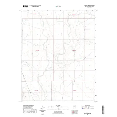
2020 Map of Buffalo Springs
USGS Topo · Published 2020About this map
Tequesquite Cr and its winding drainage system define this high plains landscape in Harding County. The map shows a transition of water sources and rural passage, anchored by the namesake Buffalo Springs and the convergence of Mosquero Cr. This arid territory is marked by a network of ranching and access routes including Salt Lakes Rd and the descriptive Back Rd, which trace the contours of the drainage basins. The sparse distribution of named features reflects the remote character of this region, where life and transit revolve around the subtle relief of the creek beds and rare permanent water sources. Local history researchers can use this survey to examine the established boundaries between township and range lines, such as t17n r30e and t17n r31e, which organize the expansive terrain.
Find a feature on this map
14 named features on this map. Tap any name to fly to it.
Don’t see what you’re looking for? This feature index may not catch every label — zoom into the map to look around manually.
Map Details
Editions of this 2020 Buffalo Springs Map
This is the sole edition of this map. No revisions or reprints were ever made.
Other maps of this area

1954 · Tucumcari
USGS Topo · 1:250,000

1958 · Tucumcari
USGS Topo · 1:250,000

1969 · Gallegos
USGS Topo · 1:24,000

1969 · Gallegos NE
USGS Topo · 1:24,000

1969 · Salitre Canyon
USGS Topo · 1:24,000
1969 · Alamosa Canyon
USGS Topo · 1:24,000

1969 · Buffalo Springs
USGS Topo · 1:24,000
1969 · Fuentes Ranch
USGS Topo · 1:24,000

1973 · Circle Bar Ranch
USGS Topo · 1:24,000
1973 · Indian Bathtub
USGS Topo · 1:24,000