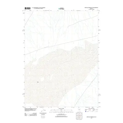
2011 Map of Buffalo Springs NE
USGS Topo · Published 2011About this map
Alkali Lake sits at the center of this 2011 survey, marking a distinct hydrographic basin in the high desert of Lander County. The landscape is characterized by its drainage patterns and the broad, flat expanse of the dry lake bed, which serves as a significant natural landmark for this portion of Nevada. Human activity is sparsely represented on the terrain, defined primarily by a few transportation corridors like Co Rd 121, which cuts through the southeastern corner of the quadrangle. The lack of concentrated settlement patterns highlights the isolation of this region at the start of the 2010s, where the primary features are the natural contours and ephemeral water bodies that define the Great Basin's topography.
Find a feature on this map
2 named features on this map. Tap any name to fly to it.
Don’t see what you’re looking for? This feature index may not catch every label — zoom into the map to look around manually.
Map Details
Editions of this 2011 Buffalo Springs NE Map
This is the sole edition of this map. No revisions or reprints were ever made.
Other maps of this area

1932 · Sonoma Range
USGS Topo · 1:250,000

1939 · Sonoma Range
USGS Topo · 1:250,000

1940 · Antler Peak
USGS Topo · 1:62,500

1943 · Antler Peak
USGS Topo · 1:62,500

1955 · Winnemucca
USGS Topo · 1:250,000

1958 · Winnemucca
USGS Topo · 1:250,000

1961 · McCoy
USGS Topo · 1:62,500

1962 · Winnemucca
USGS Topo · 1:250,000

1962 · Buffalo Springs
USGS Topo · 1:62,500
1965 · Cherry Creek SE
USGS Topo · 1:24,000