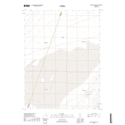
2018 Map of Buffalo Springs NE
USGS Topo · Published 2018About this map
Buffalo Valley dominates this high-desert basin in north-central Nevada, shown here in a modern survey that emphasizes the region's vast hydrographic and political divisions. The landscape is defined by its playa and wetland margins, particularly where Willow Creek drains toward the lower elevations. The map provides a clear look at the Pershing County and Lander County boundary, which cuts diagonally across the terrain through sections of T30N R41E and T29N R41E. This area is characterized by its sparse infrastructure, primarily limited to the unimproved County Road 121 in the southeastern corner. The map's detailed contouring and wetland data reflect a topography where water flow is the primary architect of the valley floor, creating a complex network of seasonal drainage patterns that define local land use and boundary lines.
Find a feature on this map
8 named features on this map. Tap any name to fly to it.
Don’t see what you’re looking for? This feature index may not catch every label — zoom into the map to look around manually.
Map Details
Editions of this 2018 Buffalo Springs NE Map
This is the sole edition of this map. No revisions or reprints were ever made.
Other maps of this area

1932 · Sonoma Range
USGS Topo · 1:250,000

1939 · Sonoma Range
USGS Topo · 1:250,000

1940 · Antler Peak
USGS Topo · 1:62,500

1943 · Antler Peak
USGS Topo · 1:62,500

1955 · Winnemucca
USGS Topo · 1:250,000

1958 · Winnemucca
USGS Topo · 1:250,000

1961 · McCoy
USGS Topo · 1:62,500

1962 · Winnemucca
USGS Topo · 1:250,000

1962 · Buffalo Springs
USGS Topo · 1:62,500
1965 · Cherry Creek SE
USGS Topo · 1:24,000