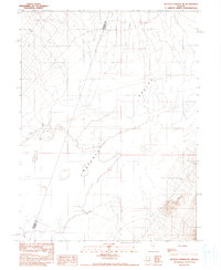
1990 Map of Buffalo Springs NE
USGS Topo · Published 1990About this map
Buffalo Valley dominates this 1990 provisional study, revealing a sparsely populated desert landscape defined by the shifting boundaries of the Dry Lake Shoreline. Situated along the border of Pershing and Lander Counties, the map documents the essential water sources that sustained early ranching or travel in this arid Great Basin environment. While the terrain is largely undeveloped, the placement of isolated features like Springs, a lone Spring, and a Well indicates the critical locations where groundwater could be reached. This survey, compiled from 1957 and 1985 aerial photographs, preserves the exact coordinate points and elevation markers of a region where the natural topography remains the primary record of human movement and boundary lines.
Find a feature on this map
6 named features on this map. Tap any name to fly to it.
Don’t see what you’re looking for? This feature index may not catch every label — zoom into the map to look around manually.
Map Details
Editions of this 1990 Buffalo Springs NE Map
This is the sole edition of this map. No revisions or reprints were ever made.
Other maps of this area

1932 · Sonoma Range
USGS Topo · 1:250,000

1939 · Sonoma Range
USGS Topo · 1:250,000

1940 · Antler Peak
USGS Topo · 1:62,500

1943 · Antler Peak
USGS Topo · 1:62,500

1955 · Winnemucca
USGS Topo · 1:250,000

1958 · Winnemucca
USGS Topo · 1:250,000

1961 · McCoy
USGS Topo · 1:62,500

1962 · Winnemucca
USGS Topo · 1:250,000

1962 · Buffalo Springs
USGS Topo · 1:62,500
1965 · Cherry Creek SE
USGS Topo · 1:24,000