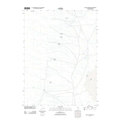
2011 Map of Buffalo Springs
USGS Topo · Published 2011About this map
Buffalo Ranch serves as a lone human landmark in this corner of Pershing County, Nevada, where the desert landscape is defined by drainage patterns and seasonal water sources. The eastern edge of the area is dominated by the sprawling bed of Alkali Lake, a topographic sink that collects runoff from the surrounding mountain canyons. A complex network of ravines, including Frank Helen Canyon and Morning View Canyon, cut across the terrain, channeling water toward the lowlands near Buffalo Springs. To the south, the hydrologic network becomes more pronounced as Big Creek and North Indian Creek converge. The naming of the various canyons, from North Hog Canyon to Wood Canyon, suggests the historical importance of these corridors for movement and resources in a high-desert environment where water and grazing land at the ranch were essential for survival.
Find a feature on this map
14 named features on this map. Tap any name to fly to it.
Don’t see what you’re looking for? This feature index may not catch every label — zoom into the map to look around manually.
Map Details
Editions of this 2011 Buffalo Springs Map
This is the sole edition of this map. No revisions or reprints were ever made.
Other maps of this area

1932 · Sonoma Range
USGS Topo · 1:250,000

1939 · Sonoma Range
USGS Topo · 1:250,000

1955 · Winnemucca
USGS Topo · 1:250,000

1958 · Winnemucca
USGS Topo · 1:250,000

1961 · Mt. Tobin
USGS Topo · 1:62,500

1961 · Leach Hot Springs
USGS Topo · 1:62,500

1962 · Winnemucca
USGS Topo · 1:250,000

1962 · Buffalo Springs
USGS Topo · 1:62,500
1965 · Cherry Creek SE
USGS Topo · 1:24,000
1965 · China Mountain
USGS Topo · 1:24,000