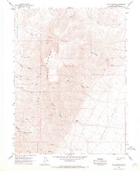
1965 Map of China Mountain
USGS Topo · Published 1967About this map
China Mountain stands as the central landmark of the high-desert terrain within the Tobin Range, a landscape defined by sharp elevation shifts and steep drainages. In the mid-1960s, this area of Pershing County remained largely undeveloped, characterized by isolated water sources and a network of primitive access routes. Hoffman Ranch appears as the primary point of settlement, located near the base of Hoffman Canyon on the edge of Buffalo Valley. The map reveals a land utilized for its scattered resources, showing a solitary Mine on the eastern slopes and numerous unnamed Spring sites that provided vital water in an arid environment. Deep canyons like Garden Canyon and Lee Canyon carve into the mountain massif, while seasonal watercourses such as China Creek and Cherry Creek highlight the drainage patterns into the surrounding basins of Pumpernickel Valley and Buffalo Valley.
Find a feature on this map
19 named features on this map. Tap any name to fly to it.
Don’t see what you’re looking for? This feature index may not catch every label — zoom into the map to look around manually.
Map Details
Editions of this 1965 China Mountain Map
2 editions found
Other maps of this area

1932 · Sonoma Range
USGS Topo · 1:250,000

1939 · Sonoma Range
USGS Topo · 1:250,000

1955 · Winnemucca
USGS Topo · 1:250,000

1958 · Winnemucca
USGS Topo · 1:250,000

1961 · Mt. Tobin
USGS Topo · 1:62,500

1961 · Leach Hot Springs
USGS Topo · 1:62,500

1962 · Winnemucca
USGS Topo · 1:250,000

1962 · Buffalo Springs
USGS Topo · 1:62,500
1965 · Cherry Creek NE
USGS Topo · 1:24,000
1965 · Smelser Pass
USGS Topo · 1:24,000