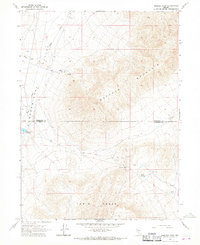
1965 Map of Smelser Pass
USGS Topo · Published 1967About this map
Buffalo Mountain and the Tobin Range dominate this high-desert landscape in northern Nevada, where the border between Humboldt and Pershing counties cuts across the rugged terrain. The 1960s survey documents a region defined by critical water sources in an arid environment, featuring Pumpernickel Reservoir, Summit Spring, and several unnamed Springs. Human activity is sparse but notable, centered on the Tipton Ranch and a remote Jeep Trail that navigates the slopes near Smelser Pass. Drainage patterns are clearly defined by Pumpernickel Creek, Ragan Creek, and Wilson Creek, which flow toward the western flats from the mountain heights. This map captures the essential infrastructure of the mid-century Great Basin, from the isolated ranching life to the industrial footprint of a small Gravel Pit.
Find a feature on this map
14 named features on this map. Tap any name to fly to it.
Don’t see what you’re looking for? This feature index may not catch every label — zoom into the map to look around manually.
Map Details
Editions of this 1965 Smelser Pass Map
2 editions found
Other maps of this area

1932 · Sonoma Range
USGS Topo · 1:250,000

1939 · Sonoma Range
USGS Topo · 1:250,000

1955 · Winnemucca
USGS Topo · 1:250,000

1958 · Winnemucca
USGS Topo · 1:250,000

1958 · Winnemucca
USGS Topo · 1:62,500

1961 · Leach Hot Springs
USGS Topo · 1:62,500

1962 · Winnemucca
USGS Topo · 1:250,000

1965 · Goldrun Creek
USGS Topo · 1:24,000

1965 · Edna Mountain
USGS Topo · 1:62,500
1965 · Brooks Spring
USGS Topo · 1:24,000