
1965 Map of Edna Mountain
USGS Topo · Published 1967About this map
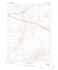
Humboldt River waters wind through a landscape defined by the heavy infrastructure of mid-century Nevada, where the dual tracks of the Southern Pacific and Western Pacific railroads parallel the newly constructed Interstate 80. This corridor through Emigrant Canyon connects the settlement of Golconda to the rail stops at Preble and Iron Point. The map documents a transition in regional transport, showing the legacy U.S. 40 alongside modern features like the Pumpernickel Interchange.
Find a feature on this map
45 named features on this map. Tap any name to fly to it.
Don’t see what you’re looking for? This feature index may not catch every label — zoom into the map to look around manually.
Map Details
Editions of this 1965 Edna Mountain Map
2 editions found
Other maps of this area

1882 · Paradise
USGS Topo · 1:250,000

1893 · Paradise
USGS Topo · 1:250,000

1932 · Sonoma Range
USGS Topo · 1:250,000

1939 · Sonoma Range
USGS Topo · 1:250,000

1940 · Antler Peak
USGS Topo · 1:62,500

1943 · Antler Peak
USGS Topo · 1:62,500

1945 · Osgood Mountains
USGS Topo · 1:62,500

1947 · Osgood Mountains
USGS Topo · 1:62,500

1955 · McDermitt
USGS Topo · 1:250,000

1955 · Winnemucca
USGS Topo · 1:250,000