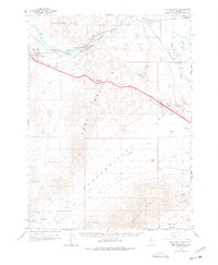
1965 Map of Edna Mountain
USGS Topo · Published 1978About this map
The Humboldt River corridor dominates this mid-1960s landscape, providing a narrow path for commerce through the Great Basin. The Southern Pacific railroad and Interstate 80 follow the water's course, cutting through Emigrant Canyon between the Osgood Mts and Edna Mountain. This vital transportation artery connects the settlement of Golconda and the siding at Preble to the wider region. Outside the river valley, the terrain transitions into the high desert basins of Pumpernickel Valley and Buffalo Valley. Historical mining activity is scattered across the slopes, with the Silver King Mine, Silver Coin Mine, and Adelaide Mine marking the search for mineral wealth. In addition to these industrial sites, the map details established grazing operations like Ryegrass Ranch and the geothermal features at Hot Springs Ranch, illustrating the intersection of mining, ranching, and geology in rural Nevada.
Find a feature on this map
40 named features on this map. Tap any name to fly to it.
Don’t see what you’re looking for? This feature index may not catch every label — zoom into the map to look around manually.
Map Details
Editions of this 1965 Edna Mountain Map
2 editions found

Other maps of this area

1882 · Paradise
USGS Topo · 1:250,000

1893 · Paradise
USGS Topo · 1:250,000

1932 · Sonoma Range
USGS Topo · 1:250,000

1939 · Sonoma Range
USGS Topo · 1:250,000

1940 · Antler Peak
USGS Topo · 1:62,500

1943 · Antler Peak
USGS Topo · 1:62,500

1945 · Osgood Mountains
USGS Topo · 1:62,500

1947 · Osgood Mountains
USGS Topo · 1:62,500

1955 · McDermitt
USGS Topo · 1:250,000

1955 · Winnemucca
USGS Topo · 1:250,000