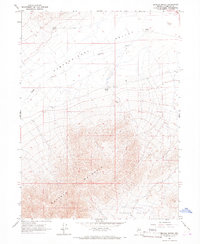
1965 Map of Brooks Spring
USGS Topo · Published 1967About this map
Pumpernickel Valley stretches across the northern expanse of this mid-1960s landscape, providing a flat basin that contrasts sharply with the massive rise of Buffalo Mountain to the south. Human presence is sparse but specific, centered around water sources and small-scale operations. Isolated outposts like Ryegrass Ranch and Kemp appear at the edges of the valley floor, while geothermal activity is indicated by Brooks Spring (Hot).
Find a feature on this map
12 named features on this map. Tap any name to fly to it.
Don’t see what you’re looking for? This feature index may not catch every label — zoom into the map to look around manually.
Map Details
Editions of this 1965 Brooks Spring Map
2 editions found
Other maps of this area

1932 · Sonoma Range
USGS Topo · 1:250,000

1939 · Sonoma Range
USGS Topo · 1:250,000

1940 · Antler Peak
USGS Topo · 1:62,500

1943 · Antler Peak
USGS Topo · 1:62,500

1955 · Winnemucca
USGS Topo · 1:250,000

1958 · Winnemucca
USGS Topo · 1:250,000

1962 · Winnemucca
USGS Topo · 1:250,000

1965 · Knight
USGS Topo · 1:24,000

1965 · Goldrun Creek
USGS Topo · 1:24,000
1965 · Golconda
USGS Topo · 1:24,000