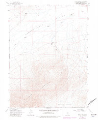
1965 Map of Brooks Spring
USGS Topo · Published 1981About this map
Pumpernickel Valley defines the northern reaches of this Great Basin landscape, where small ranching outposts like Kemp and Ryegrass Ranch sit along the valley floor. The terrain shifts dramatically as it rises toward the rugged peaks of Buffalo Mountain, which occupies the southern portion of the sheet and separates Pumpernickel from Buffalo Valley. Water sources are critical but sparse in this high desert environment, represented by Sulphur Spring, Ragan Creek, and the geothermal waters of Brooks Spring (Hot).
Find a feature on this map
13 named features on this map. Tap any name to fly to it.
Don’t see what you’re looking for? This feature index may not catch every label — zoom into the map to look around manually.
Map Details
Editions of this 1965 Brooks Spring Map
2 editions found
Other maps of this area

1932 · Sonoma Range
USGS Topo · 1:250,000

1939 · Sonoma Range
USGS Topo · 1:250,000

1940 · Antler Peak
USGS Topo · 1:62,500

1943 · Antler Peak
USGS Topo · 1:62,500

1955 · Winnemucca
USGS Topo · 1:250,000

1958 · Winnemucca
USGS Topo · 1:250,000

1962 · Winnemucca
USGS Topo · 1:250,000

1965 · Knight
USGS Topo · 1:24,000

1965 · Goldrun Creek
USGS Topo · 1:24,000
1965 · Golconda
USGS Topo · 1:24,000