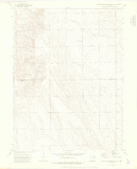
1973 Map of Buffalo Springs Ranch NE
USGS Topo · Published 1976About this map
Rock Creek winds through the southern reaches of this landscape, carving subtle relief into the High Plains of eastern Colorado. The terrain is defined by the survey boundary between Logan Co and Washington Co, marking a sparse region characterized by livestock ranching and decentralized community life in the early 1970s. The presence of the Kelly Community Center serves as a notable landmark of rural social organization in an area otherwise dominated by open range and technical infrastructure.
Find a feature on this map
7 named features on this map. Tap any name to fly to it.
Don’t see what you’re looking for? This feature index may not catch every label — zoom into the map to look around manually.
Map Details
Editions of this 1973 Buffalo Springs Ranch NE Map
3 editions found
Other maps of this area

1951 · Reiradon Hill
USGS Topo · 1:24,000

1951 · Sterling South
USGS Topo · 1:24,000

1954 · Sterling
USGS Topo · 1:250,000

1958 · Sterling
USGS Topo · 1:250,000

1972 · Glacken Hill
USGS Topo · 1:24,000

1972 · Leroy
USGS Topo · 1:24,000

1972 · Burdett
USGS Topo · 1:24,000

1973 · Buffalo Springs Ranch NW
USGS Topo · 1:24,000

1973 · Buffalo Springs Ranch NE
USGS Topo · 1:24,000

1973 · Buffalo Springs Ranch SE
USGS Topo · 1:24,000