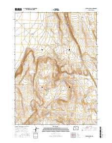
2017 Map of Buffalo Well
USGS Topo · Published 2017About this map
Christmas Lake Valley defines the northwestern expanse of this high desert terrain, where the Bureau of Land Management maintains a network of essential water sources and transit routes. Life in this arid portion of Lake County centers on isolated points like Buffalo Well, Boilout Waterhole, and S Buffalo Waterhole, which serve as vital landmarks for navigation and land management. The dramatic rise of Burma Rim separates the flatter valley floor from the undulating uplands to the east. Historical transportation patterns are visible through the alignment of the Christmas Valley Wagontire Rd and Wagontire Rd, following traditional routes across Hansen Valley. This modern survey documents the persistent reliance on early wagontire tracks and well-established draws, such as Rocky Draw, within the vast public land survey system.
Find a feature on this map
21 named features on this map. Tap any name to fly to it.
Don’t see what you’re looking for? This feature index may not catch every label — zoom into the map to look around manually.
Map Details
Editions of this 2017 Buffalo Well Map
This is the sole edition of this map. No revisions or reprints were ever made.
Other maps of this area

1955 · Crescent
USGS Topo · 1:250,000

1957 · Crescent
USGS Topo · 1:250,000

1958 · Crescent
USGS Topo · 1:250,000

1970 · Crescent
USGS Topo · 1:250,000

1981 · Fossil Lake
USGS Topo · 1:24,000

1981 · Sand Rock
USGS Topo · 1:24,000

1981 · Elk Butte
USGS Topo · 1:24,000
1984 · Poverty Basin North
USGS Topo · 1:24,000

1984 · Horse Mtn
USGS Topo · 1:24,000
1985 · Fire Lake
USGS Topo · 1:24,000