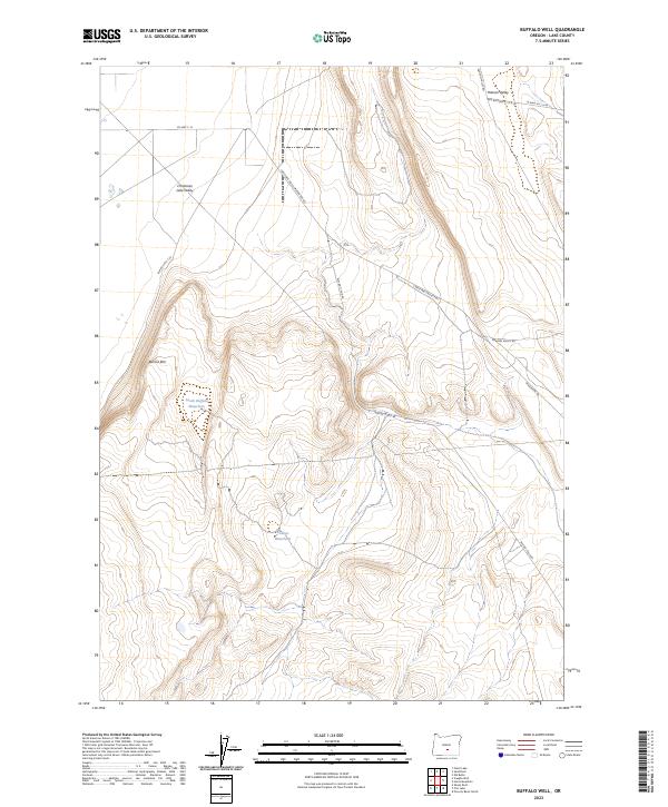
2023 Map of Buffalo Well
USGS Topo · Published 2023About this map
Christmas Lake Valley defines the northern reaches of this high-desert landscape in Lake County, where the transition from flat valley floor to elevated plateaus is marked by the prominent Burma Rim. The area's dependence on seasonal or managed water sources in an arid climate is evident through named features like South Buffalo Waterhole and Bollout Waterhole. This contemporary survey illustrates the modern road network essential for navigating the interior, including the Christmas Valley Hwy and historical routes such as the Christmas Valley Wagontire Rd. The eastern portion is dominated by the topography of Hansen Valley, where numerous BLM access roads, like Hanson Valley Rd, track through the drainage basins. The map provides a clear view of the Public Land Survey System divisions, showing the junction of Townships 27 and 28 South across Ranges 20 and 21 East.
Find a feature on this map
17 named features on this map. Tap any name to fly to it.
Don’t see what you’re looking for? This feature index may not catch every label — zoom into the map to look around manually.
Map Details
Editions of this 2023 Buffalo Well Map
This is the sole edition of this map. No revisions or reprints were ever made.
Other maps of this area

1955 · Crescent
USGS Topo · 1:250,000

1957 · Crescent
USGS Topo · 1:250,000

1958 · Crescent
USGS Topo · 1:250,000

1970 · Crescent
USGS Topo · 1:250,000

1981 · Fossil Lake
USGS Topo · 1:24,000

1981 · Sand Rock
USGS Topo · 1:24,000

1981 · Elk Butte
USGS Topo · 1:24,000
1984 · Poverty Basin North
USGS Topo · 1:24,000

1984 · Horse Mtn
USGS Topo · 1:24,000
1985 · Fire Lake
USGS Topo · 1:24,000