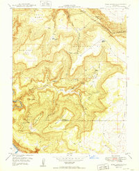
1949 Map of Bull Canyon
USGS Topo · Published 1949About this map
The United States Atomic Energy Commission collaborated on this late-1940s survey, highlighting an era of intense mineral prospecting across the high plateaus of western Colorado. The landscape is defined by massive mesas such as Monogram Mesa, Wild Steer Mesa, and Skein Mesa, where the search for carnotite and uranium ores drove the development of numerous diggings. Small-scale mining operations like the Wild Steer Mines, Jo Dandy Mine, and Teapot Dome No 2 Mine are scattered along the canyon rims, accessed by a rugged Truck Trail.
Find a feature on this map
32 named features on this map. Tap any name to fly to it.
Don’t see what you’re looking for? This feature index may not catch every label — zoom into the map to look around manually.
Map Details
Editions of this 1949 Bull Canyon Map
2 editions found
Other maps of this area

1916 · Paradox Valley
USGS Topo · 1:125,000

1922 · Paradox Valley
USGS Topo · 1:125,000

1948 · Bull Canyon
USGS Topo · 1:24,000

1948 · Horse Range Mesa
USGS Topo · 1:24,000

1948 · Uravan
USGS Topo · 1:24,000

1948 · Hamm Canyon
USGS Topo · 1:24,000

1948 · Naturita NW
USGS Topo · 1:24,000

1948 · Paradox
USGS Topo · 1:24,000

1948 · Gypsum Gap
USGS Topo · 1:24,000

1949 · Bull Canyon
USGS Topo · 1:24,000