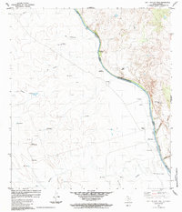
1984 Map of Bull Hollow Tank
USGS Topo · Published 1984About this map
The Rio Grande Rio Bravo serves as the international boundary on this 1984 survey, separating Webb Co, Texas, from the Mexican state of Coahuila. This arid borderland is defined by a network of ranching settlements and water sources, including the namesake Bull Hollow Tank and working sites like the Juan Reyes Windmill and Diablo Windmill. Scattered throughout the brush-covered terrain are small outposts and localities such as San Juanita, Rancho Nuevo, and El Jardin, which is marked by the high point at Tres Encinos.
Find a feature on this map
39 named features on this map. Tap any name to fly to it.
Don’t see what you’re looking for? This feature index may not catch every label — zoom into the map to look around manually.
Map Details
Editions of this 1984 Bull Hollow Tank Map
This is the sole edition of this map. No revisions or reprints were ever made.
Other maps of this area

1923 · Palafox
USGS Topo · 1:62,500

1929 · Cotulla
USGS Topo · 1:125,000

1940 · San Loranzo Creek
USGS Topo · 1:62,500

1940 · Chupadera
USGS Topo · 1:62,500

1953 · Crystal City
USGS Topo · 1:250,000

1955 · Crystal City
USGS Topo · 1:250,000

1956 · Laredo
USGS Topo · 1:250,000

1958 · Eagle Pass
USGS Topo · 1:250,000

1961 · Crystal City
USGS Topo · 1:250,000

1965 · Eagle Pass
USGS Topo · 1:250,000