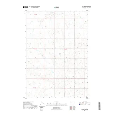
2017 Map of Bull Run Creek
USGS Topo · Published 2017About this map
Bull Run Creek and its tributaries define the drainage of this Meade County landscape, where the high plains are carved by seasonal watercourses like Sulphur Cr and Cattle Cr. The area is characterized by an expansive grid of township and range lines, reflecting the organized settlement patterns of South Dakota's interior. Human presence is concentrated along a sparse network of section-line roads, including Co Hwy Mc-23 and 160th Ave, which serve the outlying ranching interests and rural residences. Small-scale development appears in named tracks such as Kentucky Pl and Morning Sun Pl, illustrating how modern parcels have been integrated into the traditional agricultural landscape. The map captures the subtle topography of the creek beds and upland divides near Camp Cr before the terrain slopes toward larger regional basins.
Find a feature on this map
14 named features on this map. Tap any name to fly to it.
Don’t see what you’re looking for? This feature index may not catch every label — zoom into the map to look around manually.
Map Details
Editions of this 2017 Bull Run Creek Map
This is the sole edition of this map. No revisions or reprints were ever made.
Other maps of this area

1953 · Rapid City
USGS Topo · 1:250,000

1957 · Rapid City
USGS Topo · 1:250,000

1959 · Fairpoint
USGS Topo · 1:24,000

1959 · Stoneville
USGS Topo · 1:24,000

1959 · Fairpoint NW
USGS Topo · 1:24,000

1973 · Frozen Man Creek
USGS Topo · 1:24,000

1977 · Table Top Butte
USGS Topo · 1:24,000
1978 · Camp Creek
USGS Topo · 1:24,000

1978 · Bull Run Creek
USGS Topo · 1:24,000
1983 · Squaw Buttes
USGS Topo · 1:24,000