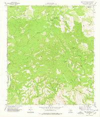
1974 Map of Bull Waterhole
USGS Topo · Published 1977About this map
The Edwards and Kinney County line crosses this sparsely inhabited ranching landscape in the mid-1970s, defined by the critical search for water in a terrain of deep draws and hollows. Bull Waterhole, Goat Waterhole, and Wickham Waterhole serve as central landmarks in an area where permanent water sources are few. The presence of Stratler Windmill and Little Windmill further underscores the reliance on groundwater for livestock in this corner of the Texas Hill Country.
Find a feature on this map
27 named features on this map. Tap any name to fly to it.
Don’t see what you’re looking for? This feature index may not catch every label — zoom into the map to look around manually.
Map Details
Editions of this 1974 Bull Waterhole Map
This is the sole edition of this map. No revisions or reprints were ever made.
Other maps of this area

1893 · Nueces
USGS Topo · 1:125,000

1896 · Nueces
USGS Topo · 1:125,000

1896 · Brackett
USGS Topo · 1:125,000

1897 · Brackett
USGS Topo · 1:125,000

1938 · Turkey Mountain
USGS Topo · 1:48,000

1943 · Turkey Mountain
USGS Topo · 1:62,500

1944 · Barksdale
USGS Topo · 1:62,500

1944 · Brackettville
USGS Topo · 1:62,500

1944 · Indian Mountain
USGS Topo · 1:62,500

1958 · Del Rio
USGS Topo · 1:250,000