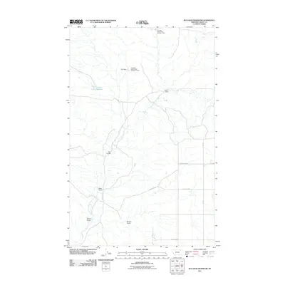
2011 Map of Bullhead Reservoir
USGS Topo · Published 2011About this map
East Fork Porcupine Creek defines the drainage patterns of this Valley County landscape, where the high plains are segmented by numerous coulees. This 2011 survey illustrates the water management infrastructure within the region, specifically noting the Fort Peck Reservation Number 1 Dam and Fort Peck Reservation Number 11 Dam, which regulate local flow near The Pass. The terrain is marked by distinctive landforms such as Three Forks and the namesake Bullhead Reservoir. The road network, including Bengochea Rd and Lustre Grain Rd, reflects the area's agricultural and rural utility, connecting remote points like Gillman Spring to the broader section-line grid. This map captures the topography of a working prairie landscape characterized by significant erosion features such as Hay Coulee and Bonnies Coulee.
Find a feature on this map
17 named features on this map. Tap any name to fly to it.
Don’t see what you’re looking for? This feature index may not catch every label — zoom into the map to look around manually.
Map Details
Editions of this 2011 Bullhead Reservoir Map
This is the sole edition of this map. No revisions or reprints were ever made.
Other maps of this area

1915 · Spring Creek
USGS Topo · 1:62,500

1918 · Porcupine Valley
USGS Topo · 1:62,500

1954 · Glasgow
USGS Topo · 1:250,000

1957 · Glasgow
USGS Topo · 1:250,000

1958 · Glasgow
USGS Topo · 1:250,000

1973 · Baylor SE
USGS Topo · 1:24,000

1973 · Larslan
USGS Topo · 1:24,000

1973 · Cameron Point
USGS Topo · 1:24,000
1983 · Spring Creek SW
USGS Topo · 1:24,000
1983 · Bullhead Reservoir
USGS Topo · 1:24,000