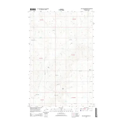
2014 Map of Bullhead Reservoir
USGS Topo · Published 2014About this map
Bullhead Reservoir sits at the heart of this Valley County landscape, surrounded by a complex network of drainage features and named coulees that define the local topography. This 2014 survey illustrates the remote character of the Frazer District, where the high ground of the Calderwood Hills and The Pass overlook the winding E Fork Porcupine Cr. The map details a landscape managed for aviation and agriculture, evidenced by Blatter Airport and a grid of rural roads such as Bengochea Rd and Grain E Rd. Significant water sources like Gillman Spring and the drainage at Three Forks represent critical landmarks in this arid region. The inclusion of numerous family-named features like Bonnies Coulee and Hay Coulee provides valuable data for researchers studying the land-use patterns of eastern Montana.
Find a feature on this map
24 named features on this map. Tap any name to fly to it.
Don’t see what you’re looking for? This feature index may not catch every label — zoom into the map to look around manually.
Map Details
Editions of this 2014 Bullhead Reservoir Map
This is the sole edition of this map. No revisions or reprints were ever made.
Other maps of this area

1915 · Spring Creek
USGS Topo · 1:62,500

1918 · Porcupine Valley
USGS Topo · 1:62,500

1954 · Glasgow
USGS Topo · 1:250,000

1957 · Glasgow
USGS Topo · 1:250,000

1958 · Glasgow
USGS Topo · 1:250,000

1973 · Baylor SE
USGS Topo · 1:24,000

1973 · Larslan
USGS Topo · 1:24,000

1973 · Cameron Point
USGS Topo · 1:24,000
1983 · Spring Creek SW
USGS Topo · 1:24,000
1983 · Bullhead Reservoir
USGS Topo · 1:24,000