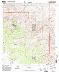
2001 Map of Bullis Spring Ranch
USGS Topo · Published 2003About this map
Lincoln National Forest land and high desert canyonlands dominate this 2001 revision, which captures the complex network of water resources required for ranching in this arid New Mexico landscape. The map reveals how isolated outposts like Bullis Spring Ranch, Terry Ranch, and Peede Ranch managed life on the land through an intricate system of water collection points. Numerous storage facilities, such as the Steve Water Storage Tank and Corner Storage Tank, appear alongside natural features like Sargent Seep and West Bear Springs. The topography is defined by deep, winding drainages including Indian Canyon, Bullis Canyon, and Sargent Canyon, which intersect near the Chaves Co Otero Co boundary. The presence of Dry Lake and various "tanks" like Foster Tank highlights the seasonal nature of water in this territory, while Rim Road provides a primary transit corridor through the broken terrain.
Find a feature on this map
29 named features on this map. Tap any name to fly to it.
Don’t see what you’re looking for? This feature index may not catch every label — zoom into the map to look around manually.
Map Details
Editions of this 2001 Bullis Spring Ranch Map
This is the sole edition of this map. No revisions or reprints were ever made.
Other maps of this area

1943 · Texas Hill
USGS Topo · 1:62,500

1945 · Texas Hill
USGS Topo · 1:62,500

1954 · Carlsbad
USGS Topo · 1:250,000

1958 · Carlsbad
USGS Topo · 1:250,000

1963 · Tanner Ranch
USGS Topo · 1:24,000

1963 · Panama Ranch
USGS Topo · 1:24,000

1965 · Lewis Peak NE
USGS Topo · 1:24,000

1965 · Lewis Peak
USGS Topo · 1:24,000

1965 · Bullis Spring Ranch
USGS Topo · 1:24,000

1965 · Pinon Ranch
USGS Topo · 1:24,000