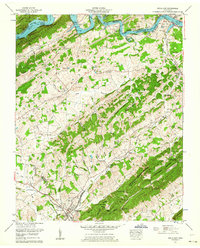
1962 Map of Bulls Gap
USGS Topo · Published 1964About this map
Bulls Gap serves as a vital rail junction where the Southern railroad lines converge at the base of Bays Mountain. This early 1960s snapshot of the Tennessee landscape reveals a rural economy transitioning around the Cherokee Lake impoundment on the Holston River. To the north, the inundation of the river valley is marked by the Cherokee Reservation Boundary, while the surrounding hills remain dotted with small family settlements like St Clair, Persia, and Otes. The land is densely textured with dozens of family burial grounds, including the McBride Cem and Malinda Bridge Cem, reflecting generations of residence in Grassy Valley. Local industry and community life are anchored by landmarks such as Austins Mill, the Price Grove Sch, and numerous country houses of worship like Mt Zion Ch and Liberty Hill Church.
Find a feature on this map
75 named features on this map. Tap any name to fly to it.
Don’t see what you’re looking for? This feature index may not catch every label — zoom into the map to look around manually.
Map Details
Editions of this 1962 Bulls Gap Map
2 editions found
Other maps of this area

1883 · Morristown
USGS Topo · 1:125,000

1892 · Greeneville
USGS Topo · 1:125,000

1893 · Morristown
USGS Topo · 1:125,000

1895 · Morristown
USGS Topo · 1:125,000

1896 · Greeneville
USGS Topo · 1:125,000

1904 · Greeneville
USGS Topo · 1:125,000

1935 · Surgoinsville
USGS Topo · 1:48,000

1935 · Rogersville
USGS Topo · 1:48,000

1935 · Lee Valley
USGS Topo · 1:24,000

1935 · McCloud
USGS Topo · 1:24,000