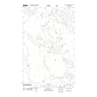
2011 Map of Bumblebee Peak
USGS Topo · Published 2011About this map
Bumblebee Peak and the surrounding high ridges of Kootenai County are documented here in this 2011 topographic survey. The landscape is defined by its complex drainage network, where the Little North Fork and Bumblebee Creek meet at the Bumblebee Meadow. This area is primarily accessed through an extensive system of Forest Service routes, including the Nat For Dev Rd 323 and Hemlock Mtn Rd, which navigate the steep elevations between Hemlock Mountain and Tepee Peak. The map highlights several remote recreational sites such as Breakwater Campground and Bumblebee Campground, as well as geological landmarks like Devils Gorge and Skull Saddle. These labels reflect the early 21st-century management of the Idaho panhandle, focusing on watershed protection and outdoor access in a region marked by notable terrain features like Shell Ridge and Browns Gulch.
Find a feature on this map
46 named features on this map. Tap any name to fly to it.
Don’t see what you’re looking for? This feature index may not catch every label — zoom into the map to look around manually.
Map Details
Editions of this 2011 Bumblebee Peak Map
This is the sole edition of this map. No revisions or reprints were ever made.
Other maps of this area

1909 · Cataldo
USGS Topo · 1:125,000

1911 · Cataldo
USGS Topo · 1:125,000

1955 · Spokane
USGS Topo · 1:250,000

1957 · Kingston
USGS Topo · 1:62,500

1957 · Kellogg
USGS Topo · 1:62,500

1958 · Spokane
USGS Topo · 1:250,000

1961 · Lakeview
USGS Topo · 1:62,500
1966 · Spyglass Peak
USGS Topo · 1:24,000
1985 · Kellogg West
USGS Topo · 1:24,000
1985 · Skitwish Peak
USGS Topo · 1:24,000