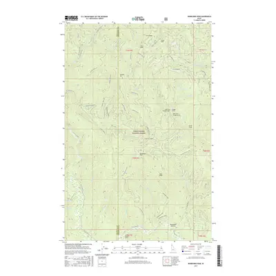
2017 Map of Bumblebee Peak
USGS Topo · Published 2017About this map
Coeur D'Alene National Forest encompasses the high country of the Bitterroot Mountains along the boundary of Kootenai and Shoshone counties. The landscape is defined by a series of prominent summits and saddles, including Bumblebee Peak, Hemlock Mtn, and Tepee Peak. A network of Forest Service roads and specialized routes, such as Laverne Creek OHV and Steamboat OHV, provide access to this steep terrain. The drainage patterns are intricate, with several branches of Cougar Gulch and the winding course of Laverne Creek cutting through the ridges. In the southern portion of the map, Bumblebee Meadow and Bumblebee Ridge mark a distinct transition in topography near Browns Gulch. This 2017 survey documents the modern management of these federal lands, highlighting the importance of the off-highway vehicle trail system for navigating the deep drainages and high passes like Skull Saddle and Laverne Saddle.
Find a feature on this map
61 named features on this map. Tap any name to fly to it.
Don’t see what you’re looking for? This feature index may not catch every label — zoom into the map to look around manually.
Map Details
Editions of this 2017 Bumblebee Peak Map
This is the sole edition of this map. No revisions or reprints were ever made.
Other maps of this area

1909 · Cataldo
USGS Topo · 1:125,000

1911 · Cataldo
USGS Topo · 1:125,000

1955 · Spokane
USGS Topo · 1:250,000

1957 · Kingston
USGS Topo · 1:62,500

1957 · Kellogg
USGS Topo · 1:62,500

1958 · Spokane
USGS Topo · 1:250,000

1961 · Lakeview
USGS Topo · 1:62,500
1966 · Spyglass Peak
USGS Topo · 1:24,000
1985 · Kellogg West
USGS Topo · 1:24,000
1985 · Skitwish Peak
USGS Topo · 1:24,000