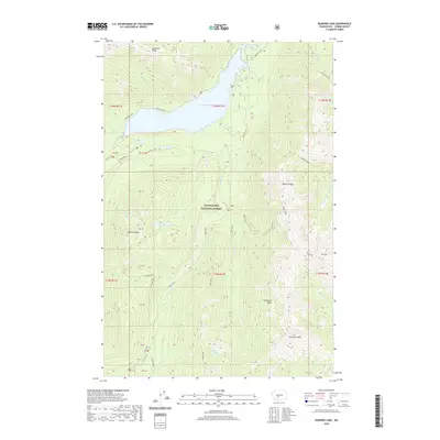
2020 Map of Bumping Lake
USGS Topo · Published 2020About this map
Bumping Lake and the rugged high-country terrain of the Snoqualmie National Forest dominate this mountain landscape. The map centers on the deep valleys carved by the Bumping River and Deep Creek, which gather runoff from prominent peaks including Mount Aix and Bismarck Peak. For those researching local industrial history, the map documents the presence of Copper City and the Richmond Mine tucked along the slopes of Miners Ridge. These labels point to a history of extraction and high-altitude settlement that preceded modern recreation. The network of waterways such as Granite Creek and Cedar Cr feeds into the central reservoir, illustrating the complex hydrology of the eastern Cascades. This 2020 survey preserves the names of natural basins like Carmelita Basin and early travel routes such as Fish Lake Way, marking the intersection of resource management and wilderness.
Find a feature on this map
45 named features on this map. Tap any name to fly to it.
Don’t see what you’re looking for? This feature index may not catch every label — zoom into the map to look around manually.
Map Details
Editions of this 2020 Bumping Lake Map
This is the sole edition of this map. No revisions or reprints were ever made.
Other maps of this area

1902 · Mount Aix
USGS Topo · 1:125,000

1904 · Mt Aix
USGS Topo · 1:125,000

1950 · Yakima
USGS Topo · 1:250,000

1958 · Yakima
USGS Topo · 1:250,000

1961 · Yakima
USGS Topo · 1:250,000

1962 · Bumping Lake
USGS Topo · 1:62,500

1962 · White Pass
USGS Topo · 1:62,500

1967 · Rimrock Lake
USGS Topo · 1:24,000
1971 · Timberwolf Mtn
USGS Topo · 1:24,000
1971 · Old Scab Mtn.
USGS Topo · 1:24,000