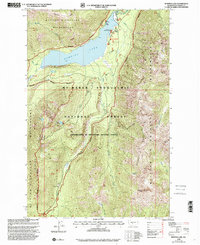
2000 Map of Bumping Lake
USGS Topo · Published 2001About this map
Bumping Lake and its surrounding wilderness define this high-altitude landscape within the Mt Baker Snoqualmie National Forest. The map documents a rugged interior network of creeks and ridges, including American Ridge and Nelson Ridge, that separate deep basins like Big Basin and Carmelita Basin. Of particular interest to local historians is the site of Copper City along Deep Creek, a remnant of the region's mining heritage located near a documented Mine. This survey, revised at the turn of the millennium, shows the infrastructure supporting the area's transition into a recreational hub, featuring the Bumping Lake Campground, various Docks, and a Boat Launch along the northern shoreline. The southern reaches are dominated by the William O Douglas Wilderness, where high peaks such as Bismarck Peak and Mt Aix overlook the headwaters of Rattlesnake Creek.
Find a feature on this map
36 named features on this map. Tap any name to fly to it.
Don’t see what you’re looking for? This feature index may not catch every label — zoom into the map to look around manually.
Map Details
Editions of this 2000 Bumping Lake Map
This is the sole edition of this map. No revisions or reprints were ever made.
Other maps of this area

1902 · Mount Aix
USGS Topo · 1:125,000

1904 · Mt Aix
USGS Topo · 1:125,000

1950 · Yakima
USGS Topo · 1:250,000

1958 · Yakima
USGS Topo · 1:250,000

1961 · Yakima
USGS Topo · 1:250,000

1962 · Bumping Lake
USGS Topo · 1:62,500

1962 · White Pass
USGS Topo · 1:62,500

1967 · Rimrock Lake
USGS Topo · 1:24,000
1971 · Timberwolf Mtn
USGS Topo · 1:24,000
1971 · Old Scab Mtn.
USGS Topo · 1:24,000