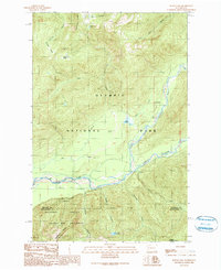
1990 Map of Bunch Lake
USGS Topo · Published 1990About this map
The North Fork Quinault River carves a deep path through this 1990 survey, marking a primary corridor where human activity meets the wilderness of Olympic National Park. The North Fork Ranger Station and North Fork Campground serve as central points for forest management and recreation along the river's edge, connected to the backcountry by the North Fork Quinault River Trail. South of the main river course, the landscape transitions into the Olympic National Forest and the protected Colonel Bob Wilderness, where the terrain is defined by steep ridges like Tshletshy Ridge and Quinault Ridge. This map captures the administrative and natural boundaries of the era, from the National Forest Boundary to the Indefinite Boundary near the Jefferson and Grays Harbor county line, showing how high-elevation water bodies like Three Lakes and Bunch Lake are tucked into the high canyons.
Find a feature on this map
29 named features on this map. Tap any name to fly to it.
Don’t see what you’re looking for? This feature index may not catch every label — zoom into the map to look around manually.
Map Details
Editions of this 1990 Bunch Lake Map
This is the sole edition of this map. No revisions or reprints were ever made.
Other maps of this area

1921 · Quinault Lake
USGS Topo · 1:62,500

1921 · Satsop
USGS Topo · 1:62,500

1947 · Mt Christie
USGS Topo · 1:62,500

1950 · Mt Christie
USGS Topo · 1:62,500

1955 · Grisdale
USGS Topo · 1:62,500

1955 · Quinault Lake
USGS Topo · 1:62,500

1956 · Kloochman Rock
USGS Topo · 1:62,500

1958 · Seattle
USGS Topo · 1:250,000

1962 · Seattle
USGS Topo · 1:250,000
1988 · Shelton
USGS Topo · 1:100,000