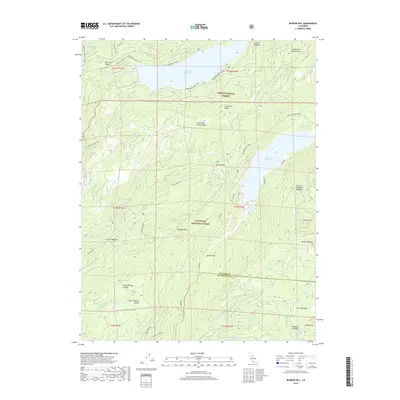
2018 Map of Bunker Hill
USGS Topo · Published 2018About this map
French Meadows Reservoir and Hell Hole Reservoir dominate this high-altitude landscape where the Tahoe National Forest meets the Eldorado National Forest. The map documents a critical hydrologic and recreational corridor along the Middle Fork American River and the Rubicon River. High ridgelines like Red Star Ridge and Chipmunk Ridge separate deep canyons and alpine meadows, including Big Meadow and Gerle Meadow. Historic transit is represented by the legendary Western States and Tevis Cup trails, which cross the northern reaches of the quadrangle. Local landmarks such as Wallace Peak, Johnnys Hill, and the ford at Hales Crossing provide specific points of interest for those tracing the development of forest service infrastructure and recreational geography in the Sierra Nevada.
Find a feature on this map
51 named features on this map. Tap any name to fly to it.
Don’t see what you’re looking for? This feature index may not catch every label — zoom into the map to look around manually.
Map Details
Editions of this 2018 Bunker Hill Map
This is the sole edition of this map. No revisions or reprints were ever made.
Other maps of this area

1889 · Pyramid Peak
USGS Topo · 1:125,000

1891 · Colfax
USGS Topo · 1:125,000

1891 · Truckee
USGS Topo · 1:125,000

1891 · Placerville
USGS Topo · 1:125,000

1891 · Pyramid Peak
USGS Topo · 1:125,000

1892 · Placerville
USGS Topo · 1:125,000

1892 · Colfax
USGS Topo · 1:125,000

1893 · Placerville
USGS Topo · 1:125,000

1893 · Truckee
USGS Topo · 1:125,000

1894 · Colfax
USGS Topo · 1:125,000