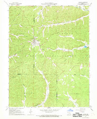
1967 Map of Bunker
USGS Topo · Published 1968About this map
Bunker serves as the central hub of this Ozark landscape, situated at the junction of three Missouri counties. The terrain is deeply carved by a network of hollows, including Ottawa Hollow and Jayhawker Hollow, which channel water toward the West Fork Black River and the Bee Fork. This survey highlights the region's reliance on both timber and topography, with the Clark National Forest blanketing much of the area. For those researching local heritage, the map identifies several rural landmarks like Little Vine Ch, Christ the King Ch, and family resting places such as Estep Cem and Parks Cem. A Bunker Lookout Tower stands as a sentinel over the Shannon County line, while natural formations like the Natural Bridge and Turner Cave mark the geological character of the southern hills.
Find a feature on this map
36 named features on this map. Tap any name to fly to it.
Don’t see what you’re looking for? This feature index may not catch every label — zoom into the map to look around manually.
Map Details
Editions of this 1967 Bunker Map
3 editions found
Other maps of this area

1941 · Stone Hill
USGS Topo · 1:62,500

1943 · Boss
USGS Topo · 1:62,500

1944 · Corridon
USGS Topo · 1:62,500

1945 · Stone Hill
USGS Topo · 1:62,500

1945 · Round Spring
USGS Topo · 1:62,500

1946 · Boss
USGS Topo · 1:62,500

1947 · Sinkin
USGS Topo · 1:48,000

1947 · Corridon
USGS Topo · 1:62,500

1949 · Round Spring
USGS Topo · 1:62,500

1949 · Rolla
USGS Topo · 1:250,000