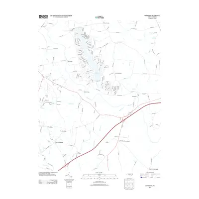
2013 Map of Bunn East
USGS Topo · Published 2013About this map
The Tar River serves as the primary drainage for this pocket of Franklin County, winding through a landscape defined by legacy road crossings and small rural centers. At Webbs Mill, the waters of Turkey Cr are captured at Webbs Millpond, marking a site of local industry near Webbs Bridge. The map shows a series of named crossroads that have long anchored the local community, including Tants Crossroads, Pace Crossroads, and Gold Valley Crossroads. Small-scale aviation is represented by both Crooked Creek Airport and Spring Paths Airport. Residential patterns are concentrated around water features like Lake Royale and Lake Sagamore, where dense street networks with names like Pawnee Dr and Sioux Dr contrast with the larger agricultural plots and timber tracts found near Seven Paths and Pine Ridge.
Find a feature on this map
214 named features on this map. Tap any name to fly to it.
Don’t see what you’re looking for? This feature index may not catch every label — zoom into the map to look around manually.
Map Details
Editions of this 2013 Bunn East Map
This is the sole edition of this map. No revisions or reprints were ever made.
Other maps of this area

1902 · Spring Hope
USGS Topo · 1:62,500

1904 · Springhope
USGS Topo · 1:62,500

1953 · Raleigh
USGS Topo · 1:250,000

1953 · Greensboro
USGS Topo · 1:250,000

1954 · Greensboro
USGS Topo · 1:250,000

1954 · Raleigh
USGS Topo · 1:250,000

1962 · Greensboro
USGS Topo · 1:250,000

1966 · Greensboro
USGS Topo · 1:250,000

1968 · Bunn West
USGS Topo · 1:24,000
1968 · Zebulon
USGS Topo · 1:24,000